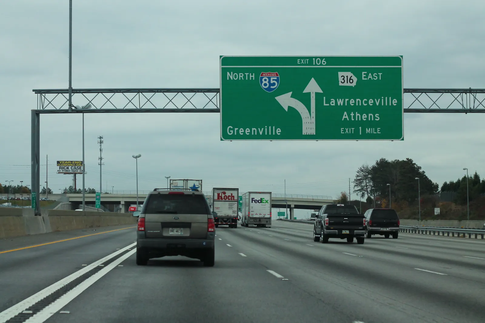
Getting around Lawrenceville: Ga. 316 from I-85 Exit 106, Ride Gwinnett Route 40 and $3 microtransit, Briscoe Field, and 1,200 free downtown parking spaces.
Last checked Oct. 6, 2026. Sources: Ride Gwinnett, the City of Lawrenceville’s parking page, Gwinnett County Airport-Briscoe Field and Georgia 511. Ride Gwinnett: 770-822-5010.
Most people get around Lawrenceville by car. The city sits on Ga. 316, Ga. 20, Ga. 124, Ga. 8 (Lawrenceville Highway) and U.S. 29, and the city notes that “all area highways converge in the center of the city.” Gwinnett County’s bus system, Ride Gwinnett, runs a local route into town and an on-demand microtransit zone. Downtown parking is free.
Who to call
- Ride Gwinnett bus customer service: 770-822-5010
- Ride Gwinnett microtransit: 770-246-4770, option 3
- Traffic and road closures on state highways: dial 511
- Downtown parking and events: City of Lawrenceville, 770-963-2414
- Plan a bus trip: RealTimeGwinnett trip planner
Main roads
- I-85: from northbound I-85, Exit 106 is Ga. 316 east, signed for Lawrenceville and Athens.
- Ga. 316 (University Parkway)
- Ga. 20 (Buford Drive)
- Ga. 124 (Scenic Highway)
- Ga. 8 (Lawrenceville Highway)
- U.S. 29, the first paved road to reach town, in 1929, according to the city’s history.
- Sugarloaf Parkway. A proposed Phase II extension would run about 7 miles from Ga. 20 to Ga. 316 with an I-85 interchange, the county says.
Road names are as the county and city use them. Live traffic, crashes and cameras for the state routes are on Georgia 511.
Downtown, decorative arches in the Depot District block trucks 12 feet tall or taller. Current work zones are on our road construction page.
Buses: Ride Gwinnett
Ride Gwinnett local routes run Monday through Saturday, according to its routes page. The ones that serve the Lawrenceville area:
| Route | Where it goes |
|---|---|
| 40 | Lawrenceville to Sugarloaf Mills to Gwinnett Place |
| 10A/10B | Sugarloaf Mills to Gwinnett Place to Doraville MARTA station |
| 50 | Buford to Sugarloaf Mills |
Track buses and plan trips on RealTimeGwinnett or the MyStop Mobile app. Pay by tapping a debit or credit card or phone, with a Breeze Card, or with exact change; card and Breeze riders get four free transfers between routes, according to the fare page. Passes are sold at Ride Gwinnett Customer Service, 3525 Mall Blvd., Suite 5-C, in Duluth.
Microtransit: $3 rides on demand
Ride Gwinnett microtransit is a shared van or shuttle you book on your phone. Trips cost $3 per person and must start and end inside a designated zone; Lawrenceville has one, shown on the county’s zone map.
- Hours: 6 a.m. to 8 p.m. Monday through Saturday; trips must finish by 8 p.m.
- Book in the Ride Gwinnett app, on the web or at 770-246-4770, option 3, up to 24 hours ahead.
- Pay in the app, by card, Breeze Card or exact cash.
- To leave the zone, ride microtransit to a local route such as Route 40.
Getting to the airport
For airline flights, use Hartsfield-Jackson Atlanta International Airport. By transit, take Ride Gwinnett to Doraville Station, then MARTA rail; plan the trip with MARTA’s trip planner.
Gwinnett County Airport-Briscoe Field is about 500 acres northeast of the city, with one 6,000-by-100-foot runway for light general aviation and most corporate jets, a control tower open 7 a.m. to 9 p.m., and about 300 based aircraft, according to the county.
Walking and biking
Downtown’s Heritage Trail links the square to Rhodes Jordan Park, and the county’s paved park trails and the Harris Greenway are listed on our walking and biking trails page. The city is building a trailhead for the Lawrenceville Gateway Trail near Georgia Gwinnett College.
Parking downtown
The city’s EZ-2 Park program lists more than 1,200 free public spaces downtown, in color-coded decks and lots:
| Lot or deck | Address |
|---|---|
| Blue Deck | 225 Luckie St. |
| Purple Deck | 147 E. Crogan St. |
| Green Lot | 210 Luckie St. |
| Gold Lot | 70 S. Clayton St. |
| Navy Lot | 69 S. Clayton St. |
| Silver Lot | 252 S. Clayton St. |
| Orange Lot | 112 W. Pike St. |
| Gray Lot | 245 N. Perry St. |
| Red Lot | 400 N. Clayton St. |
Some lots close for special events; sign up for the city’s road closure alerts or check each event page. The city’s parking page does not post time limits or enforcement hours; follow the signs at each space. Download the downtown parking guide (PDF).
What this means for you
- From I-85, Exit 106 and Ga. 316 east bring you to town.
- No car? Route 40 and the $3 microtransit zone cover much of Lawrenceville.
- Park free downtown in the Blue Deck on Luckie Street or the Purple Deck on Crogan Street.
More: road construction and closures and moving to Lawrenceville.
Frequently asked questions
Is there a bus in Lawrenceville, Georgia?
Yes. Ride Gwinnett Route 40 runs from Lawrenceville to Sugarloaf Mills and Gwinnett Place, Monday through Saturday, and Ride Gwinnett microtransit offers $3 on-demand rides within a Lawrenceville zone. Customer service: 770-822-5010.
Is parking free in downtown Lawrenceville?
Yes. The city says downtown has more than 1,200 free public spaces in color-coded decks and lots, including the Blue Deck at 225 Luckie St. and the Purple Deck at 147 E. Crogan St.
What airport is in Lawrenceville?
Gwinnett County Airport-Briscoe Field, northeast of the city, with one 6,000-foot runway for light general aviation aircraft and most corporate jets, according to the county.
How do I get to Lawrenceville from I-85?
Take Exit 106 for Ga. 316 east, signed for Lawrenceville and Athens.
How much is Ride Gwinnett microtransit?
$3 a trip per person, Monday through Saturday, 6 a.m. to 8 p.m. Book in the Ride Gwinnett app or at 770-246-4770, option 3.
Have your say